When a crisis occurs in a school, business or government building, the rapid and efficient response of emergency teams is crucial. While many public spaces have multi-layered security plans in place, they often fail at the first level: they don’t have an accurate, up-to-date emergency response map or floorplan for first responders to follow. This deficiency can significantly hinder response efforts, causing delays and confusion that jeopardize the safety and security of everyone involved.
Critical incident mapping addresses this challenge by providing accurate, up-to-date maps that are compatible with many of the security platforms, mobile apps, 911 center/PSAP systems, and public safety software suites used by first responders. They are more than simple floor plans – they are essential tools that guide responders through unfamiliar locations with precision and provide a single, common operating picture to work from.
RELATED: New Approaches to Incident Management that Empower First Responders
From the Military to the Schoolhouse
The roots of this innovative tool can be traced back to U.S. military special ops forces, who invented a mapping technique called Gridded Reference Graphics (GRGs) to navigate uncharted terrains. Unified imagery is a fundamental tool for military missions – whether using a terrain model, a paper map, or a digital image, common imagery ensures missions are handled quickly and precisely.
In recent years, the GRG method has been domesticated into U.S. public safety with significant impact.
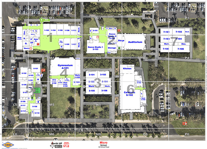
The overall concept is simple: Every map is equipped with a grid, labeled with letters and numbers along the X & Y coordinates. Doors are numbered, buildings are labeled, and much like a simple game of Battleship®, operators can use this information to talk through a location, even if they’ve never been there before.
Valuable Features of Emergency Response Maps
To be effective in the field, critical incident maps incorporate several essential elements:
- GeoRelevant Floor Plans: Outlining the basic building structure and layout.
- Oriented “True North:” Enabling better comprehension and coordination.
- Detailed Grids and Templates: Assisting in spatial orientation and communication.
- Identification of Key Landmarks and Features: Helping to identify key locations that responders might need, such as critical utility locations, key boxes, automated external defibrillators, and trauma kits.
- Custom Labels and Nomenclature: Providing precise location descriptions in the language and labels used by the building staff and residents.
- Clear Markings of Navigation Points: Enabling easy identification of exits, stairwells, and hallways.
- Best Available Aerial Imagery: Offering a comprehensive view of the area.
The Challenges of Existing Mapping Data
First responders entrusted with public safety often face challenges due to outdated and inaccurate building schematics and floor plans. It seems obvious that 9-1-1 centers, law enforcement, paramedics, and EMTs should have accurate maps of their area schools, but shockingly, they do not.
According to the National Center for Education Services, the average age of public school buildings in the United States is 42 years old. The floor plans on file are often the original building blueprints and schematics, which were never meant to be used to communicate emergency response. These outdated maps frequently fail to reflect changes like building additions, renovations, or room reconfigurations over the years. As a result, precious minutes are lost trying to locate “the kindergarten wing” or “Room 212,” whose locations may have changed multiple times since the original floor plan was drawn up.
The Common Language for Emergency Response
Compounding this problem further is the fact that different groups of first responders rarely use the same technologies — to the point that they can’t even communicate during crisis incidents. Schools have their own security tools, notification tools, mass texting systems, video management and more. For example, during the Sandy Hook mass shooting tragedy, over a dozen local, state, and federal agencies responded to the scene. However, they faced significant challenges due to the use of different communication tools. The municipal police department relied on proprietary Computer-aided Dispatch (CAD) systems, while the county police and state police departments used their own isolated technologies. Fire departments and 911 services also operated on separate systems. As a result, these departments struggled to interact efficiently across their radios, hindering a coordinated response.
RELATED: University Emergency Management’s Response Role in Civil Unrest
Critical incident mapping ensures that all teams – from internal security to 9-1-1 centers and law enforcement officers – operate from a unified understanding of the location. For example, a panic button only provides a location to 9-1-1. But with critical incident mapping, a 9-1-1 dispatcher and the person on the ground can communicate more effectively. Using terms like “door 3, grid square 6,” both parties understand precisely where to focus their response efforts because they share the same mapping software.
This shared language during crisis events enable:
- Reduced Response Times: Quick and efficient navigation directly translates to faster response.
- Improved Command and Control: Ensures that all teams are on the same page during an incident.
- Clear Communication: A common operational language minimizes miscommunication.
Conclusion: A Step Towards Safer Communities
Critical incident mapping is more than a technological advancement; it’s a commitment to public safety. Clear, accessible, and detailed maps empower first responders to act swiftly and confidently, making our school communities safer and more resilient.
Mike Rodgers is the CEO and co-founder of Critical Response Group (CRG).